Sensor Fusion

① Sensor fusion - general

By sensor fusion we mean the interaction of different sensors for the documentation or monitoring of the infrastructure, whereby several modes of transport could also be involved: Rail, road and water. Fibre optic sensors can be used as well as echo sounder measurements and sensors for 3D mapping. In most cases, relative statements will not be sufficient, but absolute values are also decisive. For some tasks, the use of drone flights can also provide additional information.
Why sensor fusion for monitoring infrastructure will become more and more important in the future: the video message in the following video ends with the sentence: "Lets save our infrastructure for our next generation". And we don't even have to look as far as Indonesia or Taiwan: we can also find some examples here or in neighbouring countries.
 

Video in cooperation with our partner MEGUMI in Indonesia:

② FOS - Applications

DGNSS has been working on the subject of FOS for almost 10 years and has already completed several projects to the
complete satisfaction of the domestic railway company ÖBB. A wide range
of application possibilities with different sensor types has emerged

Measuring principle:

- Fibre-optic known in measurement technology since 1980
- all measurement systems are based on the backscatter principle in fibre-optic optical waveguides
- invisible light is coupled into optical waveguides and transported
- smallest parts of it are reflected and reflected back at every point of the fibre
- this is measured and provides information about strain, pressure and temperature
- central measuring unit evaluates and displays the corresponding measured variables
- no power supply required at the measuring point
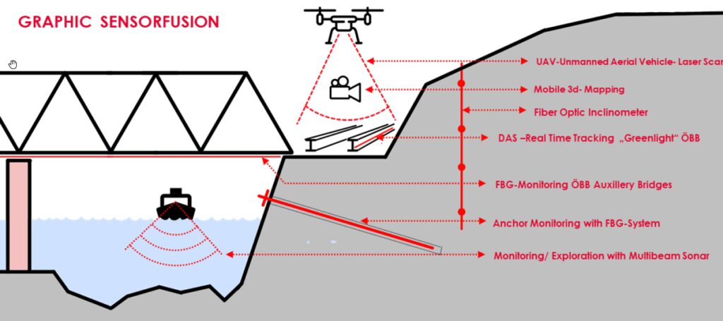
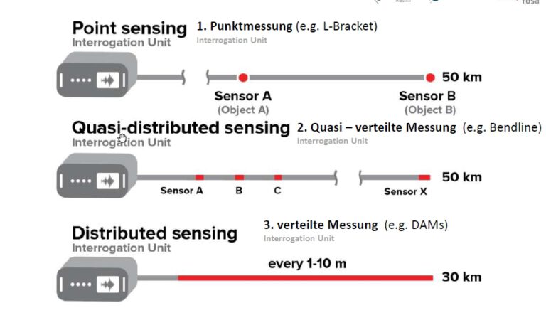
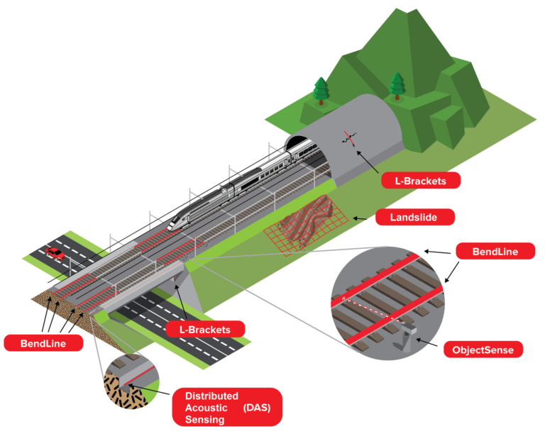
Depending on the application, the sensors are arranged differently: Point sensing, for example, is suitable for crack detection, with quasi-distributed sensing several sensors are arranged one behind the other (bendlines for auxiliary bridges) or the entire cable is actually the sensor in the case of stone chip detection, etc.

For auxiliary bridges, the bendlines are additionally combined with object sensing: : permanent
"fibre optic levelling": for discrete objects
A combination with a fibre-optic camera is always interesting if, after exceeding a warning limit,
you want to see immediately whether there is a cause.
Combination of different sensors in infrastructure projects:

③ Mobile Mapping

Mobile mapping will be the preferred method for documenting infrastructure corridors in the future, regardless of whether they are rail or road corridors. Both modes of transport have already carried out several pilot projects with this technology in recent years. For the track, a track-bound vehicle is recommended (e.g. VT100 by Plasser & Theurer), for the road, the necessary instruments are usually located on a special car van.

Vehicle-based combination of sensors:

- GNSS (satellite positioning)
- IMU (Inertial measurement Unit - spatial orientation)
- 3x 2D laser scanner - (up to 1 million pts per sec)
- image information (panoramic camera system)
- measuring frequency 250 Hz,
- combination of all sensor data into a homogenised georeferenced point cloud

Result is the provision of a comprehensive basis for documentation, planning and
algorithmic analysis of change
Besides the output of georeferenced 3D laser data, the output of georeferenced
3d image data is also a possible use case.